
[mkgmap-dev] Possible solution for deformed polygons
From Andrzej Popowski popej at poczta.onet.pl on Sun Nov 24 15:52:41 GMT 2013
Hi WanMil,
> So instead of using Garmins housenumber search you want to add
> a small road for each POI named with "${streetname} ${housenumber}'?
Yes. Only including house number in street name could be limited to
cases, where it contains non-numeric characters. And there should be a
possibility to add house number numeric value to this street as a number
for indexing, not only as a part of the name.
> * Wouldn't that blow up the index size?
Probably, but it should work. I have an transparent overlay with nearly
2.5 millions of address POI and index img for Mapsource is about 30MB.
Quite manageable value.
> * Must each invisible road be connected to the rest of the road
> network?
> Otherwise I expect that Garmin is not able to route to the
> housenumbered streets and we get thousands of routing islands?
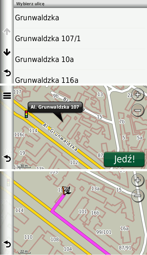
These roads don't have to be routable, only searchable. In my overlay I
use roads type 0x13 with length of about 12m. Roads aren't connected to
any network and whole overlay is not routable. GPS finds an address on
non-routable road and then creates a route like to a POI, which is not
placed on a road. See attached screen shoots from nuvi.
> * mkgmap would have to modify/create a TYP file with one invisible
> road type. Should this be processed by mkgmap or is that a task of
> the map generator to ensure that the additional road type is
> invisible?
In my opinion mkgmap should provide generic tools and the rest should be
left to map developer.
--
Best regards,
Andrzej
-------------- next part --------------
A non-text attachment was scrubbed...
Name: addr1.png
Type: image/png
Size: 49953 bytes
Desc: not available
URL: <http://www.mkgmap.org.uk/pipermail/mkgmap-dev/attachments/20131124/bbbeb02b/attachment-0001.png>
- Previous message: [mkgmap-dev] Possible solution for deformed polygons
- Next message: [mkgmap-dev] o5m plugin for JOSM
- Messages sorted by: [ date ] [ thread ] [ subject ] [ author ]
More information about the mkgmap-dev mailing list