
[mkgmap-dev] Splitter feature request
From Carlos Dávila carlos at alternativaslibres.org on Sun Dec 3 11:26:52 GMT 2023
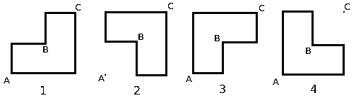
Hi all

I usually let splitter decide tiles based on max-nodes value, but for
some maps I need to supply splitter an areas.list file which I adjust
manually. Reasons for that include reducing the total number of tiles,
avoiding cutting of some islands and separating right/left hand side
driving areas or reducing number of tiles with both sides driving. For
these cases, it would be helpful to be able to build "L shaped tiles",
as in the attached image. I think these tiles could be defined by three
coordinates (A,B,C), which would define the two rectangles in which the
L shaped tile can be split, and a switch (1,2,3,4) to determine de
orientation of the "L".

1: tile = A-lat, A-lon to B-lat, B-lon + A-lat,B-lon to C-lat,C-lon

2: tile = B-lat, A-lon to C-lat, C-lon + A-lat,B-lon to B-lat,C-lon

3: tile = A-lat, A-lon to B-lat, B-lon + B-lat,A-lon to C-lat,C-lon

4: tile = A-lat, A-lon to C-lat, B-lon + A-lat,B-lon to B-lat,C-lon

This raises several questions. First of all, if is feasible, then if it
is worth the effort to implement it, how would if affect splitter
performance and if it makes sense for other users. Perhaps it could be a
first step towards irregular tiles...
-------------- next part --------------
A non-text attachment was scrubbed...
Name: L shaped tiles.png
Type: image/png
Size: 633 bytes
Desc: not available
URL: <https://www.mkgmap.org.uk/pipermail/mkgmap-dev/attachments/20231203/ae815e52/attachment.png>
- Previous message: [mkgmap-dev] Commit r4916: sortResource_v3.patch (with updated date in comment) by Ticker Berkin
- Next message: [mkgmap-dev] Splitter feature request
- Messages sorted by: [ date ] [ thread ] [ subject ] [ author ]
More information about the mkgmap-dev mailing list