
[mkgmap-dev] Tiles pruned in DEM map
From Carlos Dávila cardavilam at gmail.com on Thu Dec 17 22:44:20 GMT 2020
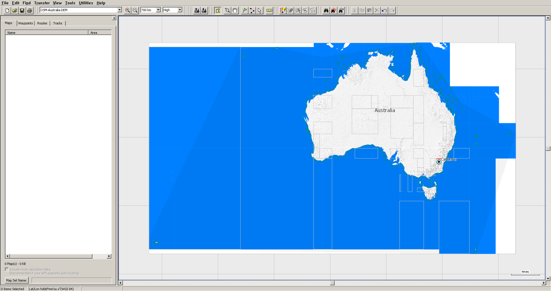
I build several types of map (OSM, OSM+contour lines, maps for trucks
and OSM+DEM) for the same area, using same input files. I split
country.o5m with splitter and then use the same template.args output by
splitter for all maps, just changing mapname for the different types of
map. Given that, all resulting mapsets should have the same tiles, but
tiles in DEM map are smaller than in the other types. They share part of
the boundaries (usually two of them) with other types, but other
boundaries are moved in, reducing displayed tile size. See attached
screenshots. However, file size is the same (discounting *.DEM) for each
tile in *.gmap subfolders.

Command is quite similar for OSM and OSM+DEM maps:

java -Xmx27G -ea -Dlog.config=logging.properties -jar mkgmap.jar -c
opciones_comunes $CODEPAGE --gmapi --bounds=bounds.zip
--precomp-sea=sea.zip --route --country-name=$PAIS --country-abbr=${ABR}
--area-name=$MAPA --family-name="OpenStreetMap $MAPA"
--family-id=1${FID} --product-version=$VERSION --series-name="OSM-$MAPA"
--overview-mapname=${ABR}1${FID} --overview-mapnumber=${GRUPO}1${FID}000
--name-tag-list=$NAMETAG --process-destination --process-exits
--housenumbers --reduce-point-density=4 --polygon-size-limits="24:12,
18:10, 16:0" --order-by-decreasing-area --add-pois-to-areas
--report-similar-arcs --report-dead-ends=2 --link-pois-to-ways
--location-autofill=is_in,nearest --drive-on=detect,$DRIVEON
--check-roundabouts --check-roundabout-flares --license-file=license_OSM
--copyright-file=copyright $LANGUAGE --road-name-config=${CONFIG}
--style=mio --check-styles -c $pais.args tmp/${ABR}1${FID}.txt

java --Xmx27G -ea -Dlog.config=logging.properties -jar mkgmap.jar
--dem=hgt/LIDAR,hgt/ALOS,hgt/VIEW1,hgt/SRTM1,hgt/EU-DEM,hgt/VIEW3,hgt
--dem-poly=polygons/$pais.poly --dem-dists=3312,6624,9936,13248,26512
--overview-dem-dist=128000 -c opciones_comunes $CODEPAGE --gmapi
--show-profiles=1 --bounds=bounds.zip --precomp-sea=sea.zip --route
--country-name=$PAIS --country-abbr=${ABR} --area-name="$MAPA"
--family-name="OSM $MAPA DEM" --family-id=5${FID}
--product-version=$VERSION --series-name="OSM-$MAPA-DEM"
--overview-mapname=${ABR}5${FID} --overview-mapnumber=${GRUPO}5${FID}000
--name-tag-list=$NAMETAG --process-destination --process-exits
--housenumbers --reduce-point-density=4 --polygon-size-limits="24:12,
18:10, 16:0" --order-by-decreasing-area --add-pois-to-areas
--link-pois-to-ways --location-autofill=is_in,nearest
--drive-on=detect,$DRIVEON --check-roundabouts --check-roundabout-flares
--license-file=license_OSM_${HGT} --copyright-file=copyright $LANGUAGE
--road-name-config=${CONFIG} --style=mio --remove-ovm-work-files=true -c
${pais}-DEM.args tmp/${ABR}5${FID}.txt

Both OSM and OSM+DEM maps can be downloaded from
https://alternativaslibres.org/en/downloads.php#Oceania

Any idea why this happens?

-------------- next part --------------
A non-text attachment was scrubbed...
Name: Australia DEM.png
Type: image/png
Size: 262763 bytes
Desc: not available
URL: <http://www.mkgmap.org.uk/pipermail/mkgmap-dev/attachments/20201217/7e4ad011/attachment-0002.png>
-------------- next part --------------
A non-text attachment was scrubbed...
Name: Australia OK.png
Type: image/png
Size: 78921 bytes
Desc: not available
URL: <http://www.mkgmap.org.uk/pipermail/mkgmap-dev/attachments/20201217/7e4ad011/attachment-0003.png>
- Previous message: [mkgmap-dev] mkgmap-r4589 download
- Next message: [mkgmap-dev] Tiles pruned in DEM map
- Messages sorted by: [ date ] [ thread ] [ subject ] [ author ]
More information about the mkgmap-dev mailing list