
[mkgmap-dev] Complex ocean polygon hiding the islands
From Gerd Petermann gpetermann_muenchen at hotmail.com on Sat Feb 28 07:45:59 GMT 2015
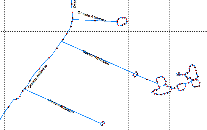
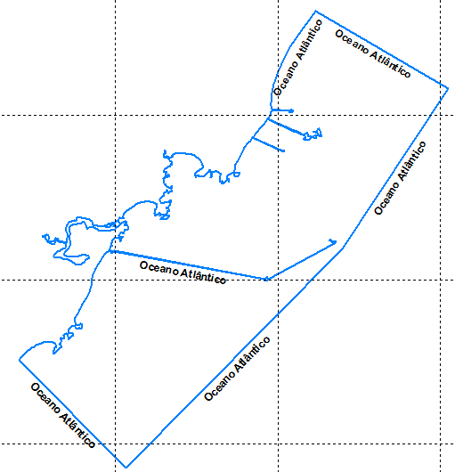
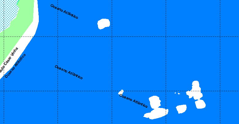
Hi Alexandre,

yes, simplification happens in various places. The reasons are limits in the Garmin
format as well as optimization of the img file size.

1) The Garmin img format uses a raster with ~2.3 m distance at resolution 24.
I think of it as a bed of nails, you can draw straigt lines between any of the nails.
Details below this resolution are removed. We use two different algos for lines and shapes
here, so expect slightly different results for outlines.
2) The Garmin format doesn't allow a single polygon with more than 255 points, so mkgmap
has to split a complex polygon into smaller pieces.
3) For lower resolutions, the raster is less precise, means, for 23 points are ~4.6m, 22 -> ~9.6m and
so on.
4) For lower resolutions, a variant of the Douglas-Peucker-Algo is used to reduce the img size.
You can change the effect of this by using the "Optimization options":
http://www.mkgmap.org.uk/doc/options

See also
http://en.wikipedia.org/wiki/Ramer%E2%80%93Douglas%E2%80%93Peucker_algorithm

Gerd

Date: Sat, 28 Feb 2015 01:33:18 -0300
From: alexandre.loss at gmail.com
To: mkgmap-dev at lists.mkgmap.org.uk
Subject: [mkgmap-dev] Complex ocean polygon hiding the islands

Hi guys,
Please see if any of you can help me ...
I have an ocean polygon with multiple edges and in the middle of these there are several islands that are in fact holes in the polygon.Here's an example:


Showing only the contour lines, the polygon is drawn as follows:


Zooming...

When I compile the map, the islands/holes are overlapped by the sea.I noticed that when the polygon is less complex, this overlapping phenomena doesn't happens. Its looks like mkgmap simplifies complex polygons.

Is there any option that I can use in mkgmap to respect the layout of complex ocean polygons?
By the way, if this isn't the right list to ask this kind of question, please let me know cause I'm new here.
Thanks.
Alexandre

_______________________________________________
mkgmap-dev mailing list
mkgmap-dev at lists.mkgmap.org.uk
http://www.mkgmap.org.uk/mailman/listinfo/mkgmap-dev
-------------- next part --------------
An HTML attachment was scrubbed...
URL: <http://www.mkgmap.org.uk/pipermail/mkgmap-dev/attachments/20150228/c7ea8bc3/attachment-0001.html>
-------------- next part --------------
A non-text attachment was scrubbed...
Name: image.png
Type: image/png
Size: 25959 bytes
Desc: not available
URL: <http://www.mkgmap.org.uk/pipermail/mkgmap-dev/attachments/20150228/c7ea8bc3/attachment-0003.png>
-------------- next part --------------
A non-text attachment was scrubbed...
Name: image.png
Type: image/png
Size: 27797 bytes
Desc: not available
URL: <http://www.mkgmap.org.uk/pipermail/mkgmap-dev/attachments/20150228/c7ea8bc3/attachment-0004.png>
-------------- next part --------------
A non-text attachment was scrubbed...
Name: image.png
Type: image/png
Size: 21450 bytes
Desc: not available
URL: <http://www.mkgmap.org.uk/pipermail/mkgmap-dev/attachments/20150228/c7ea8bc3/attachment-0005.png>
- Previous message: [mkgmap-dev] Complex ocean polygon hiding the islands
- Next message: [mkgmap-dev] Complex ocean polygon hiding the islands
- Messages sorted by: [ date ] [ thread ] [ subject ] [ author ]
More information about the mkgmap-dev mailing list