
[mkgmap-dev] Misplaced boundary POI
From dfjkman at gmail.com dfjkman at gmail.com on Mon Jul 5 19:10:48 BST 2021
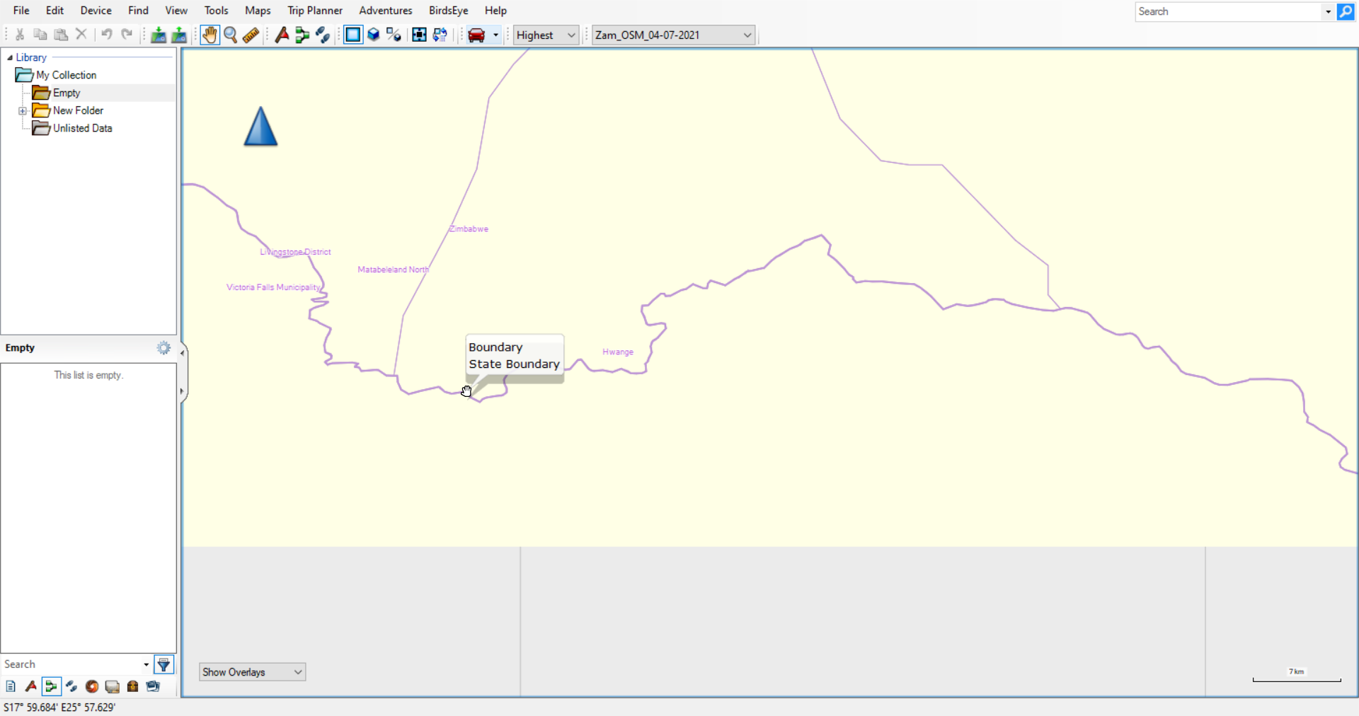
Hi Gerd,


Have found similar instances with provincial and district boundaries that
border Zambia, namely Rhumphi
(https://www.openstreetmap.org/relation/7342877) on the border with Zambia
and Malawi, Matabeleland North, Hwange and Kariba all provinces of Zimbabwe.
It would appear that where the boundary is incomplete and the section that
is there is relatively small the POI generated by --add-pois-to-areas ends
up outside the boundary. Attached image shows the area around Victoria Falls
showing the misplaced Hwange and Matabeleland North as well as the Zimbabwe
label.


Kind regards,

Dave


From: dfjkman at gmail.com <dfjkman at gmail.com>
Sent: 05 July 2021 18:54
To: 'mkgmap-dev at lists.mkgmap.org.uk' <mkgmap-dev at lists.mkgmap.org.uk>
Subject: Misplaced boundary POI


Hi Gerd,


The other day I noticed that the country name along the boundary between
Zambia and Zimbabwe was misplaced in 2 regions, see the attached images. The
name also switches at different detail levels in BaseCamp, at Medium and
High it shows Zimbabwe north of the border and at Higher and Highest it
shows Zambia. The POI to the east would appear to have both Zambia and
Zimbabwe assigned to it while to the west, near Livingstone, would appear to
be 2 separate POIs.


I have created a map with only the boundaries to show this clearly as it is
missed when the map has more detail in it. The map was created from
zambia-latest.osm.pbf from Geofabrik and split using Splitter version 615
with the following options:


java -jar -Xmx2g  C:\Users\Dave\Documents\Maps\Utils\splitter\splitter.jar

--output=pbf

                              --resolution=13

                              --description="ZM_OSM Map"

                              --wanted-admin-level=5

                              --mapid=2635

                              --max-nodes=2600000


The map was created with mkgmap-r4801, although I have noticed it with
earlier versions. Options as follows:


Java -jar -Xmx7g C:\Users\Dave\Documents\Maps\Utils\mkgmap\mkgmap.jar

                              --keep-going

                              --latin1

                              --add-pois-to-areas

                              --gmapi

--style-file='C:\Users\Dave\Documents\Maps\Styles\boundaries'

                              -c
C:\Users\Dave\Documents\Maps\Zambia\Split_Files\template.args

In  the basic boundary style I have the following files:

Options

               levels = 0:24, 1:22, 2:20, 3:18

               overview-levels = 4:17, 5:16, 6:15, 7:14, 8:13

Lines

               boundary=administrative & admin_level<3 [0x1e resolution 12]

Points

               boundary = administrative & mkgmap:area2poi = true &
admin_level = 2               [0x1400 resolution 16-20]

               <finalize>

name = * {name '${name}'}


This is not something that overly worries me but if it happens here it may
happen elsewhere and be missed. I have not analysed my maps to see if it
happens with other provincial or district boundaries.


Kind regards,

Dave

-------------- next part --------------
An HTML attachment was scrubbed...
URL: <http://www.mkgmap.org.uk/pipermail/mkgmap-dev/attachments/20210705/cc2046b4/attachment-0001.html>
-------------- next part --------------
A non-text attachment was scrubbed...
Name: Boundary_3.png
Type: image/png
Size: 153566 bytes
Desc: not available
URL: <http://www.mkgmap.org.uk/pipermail/mkgmap-dev/attachments/20210705/cc2046b4/attachment-0001.png>
- Previous message: [mkgmap-dev] Misplaced boundary POI
- Next message: [mkgmap-dev] Misplaced boundary POI
- Messages sorted by: [ date ] [ thread ] [ subject ] [ author ]
More information about the mkgmap-dev mailing list