
[mkgmap-dev] mkgmap-dev Digest, Vol 153, Issue 40 Resolution 23 raster problems
From Gerd Petermann gpetermann_muenchen at hotmail.com on Fri Apr 23 19:44:02 BST 2021
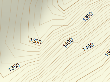
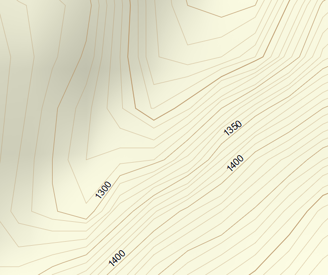
Hi Felix,

for mkgmap it would be best if the generated contour line nodes where exactly on positions in the Garmin res 23 or maybe even res 22 positions. In that case the rounding in mkgmap would not change the generated lines.
I have no idea if any generator is able to do that, it probably adds some complexity to the calculations.

Gerd

________________________________________
Von: mkgmap-dev <mkgmap-dev-bounces at lists.mkgmap.org.uk> im Auftrag von Felix Hartmann <extremecarver at gmail.com>
Gesendet: Freitag, 23. April 2021 17:47
An: john at the-thorns.org.uk; Development list for mkgmap
Betreff: Re: [mkgmap-dev] mkgmap-dev Digest, Vol 153, Issue 40 Resolution 23 raster problems

the problem is at some points - that the lines interchange at resolution 23. I know the main problem is phyghtmap. Groundtruth and gnuplot with b-spline interpolation can do this much better. But at resolution 24 still never lines intersect, at resolution 23 they do.
(the commenting of the wrong angle fixer didn't seem to help or change anything - I have to compare tomorrow again however. Just locked myself out of my compile server somehow entering the password wrong too often).
Yes very steep and 10m equidistance which is not suited for such steep slopes - but it's possible to create much better contourlines (as seen from the contourlines on kleineisel.de<http://kleineisel.de> - they never intersect also at resolution 23).

On Fri, 23 Apr 2021 at 21:38, John Thorn <johnrthorn at gmail.com<mailto:johnrthorn at gmail.com>> wrote:
I don't think this can be improved.

As I understand it, internally Garmin devices hold coordinates in the number of bits specified in the level.

So 24 bits has a resolution of 2.4 metres, 23 bits has a resolution of 4.8 meters and so on. If you look carefully, all the vertices of the lines lie on a square grid.

Having said that, that must be a very steep slope - unless something else is creating the granularity.

On Fri, 23 Apr 2021 at 12:06, <mkgmap-dev-request at lists.mkgmap.org.uk<mailto:mkgmap-dev-request at lists.mkgmap.org.uk>> wrote:
Send mkgmap-dev mailing list submissions to
        mkgmap-dev at lists.mkgmap.org.uk<mailto:mkgmap-dev at lists.mkgmap.org.uk>

To subscribe or unsubscribe via the World Wide Web, visit
        https://www.mkgmap.org.uk/mailman/listinfo/mkgmap-dev
or, via email, send a message with subject or body 'help' to
        mkgmap-dev-request at lists.mkgmap.org.uk<mailto:mkgmap-dev-request at lists.mkgmap.org.uk>

You can reach the person managing the list at
        mkgmap-dev-owner at lists.mkgmap.org.uk<mailto:mkgmap-dev-owner at lists.mkgmap.org.uk>

When replying, please edit your Subject line so it is more specific
than "Re: Contents of mkgmap-dev digest..."
Today's Topics:

   1. Resolution 23 raster problems (Felix Hartmann)


---------- Forwarded message ----------
From: Felix Hartmann <extremecarver at gmail.com<mailto:extremecarver at gmail.com>>
To: Development list for mkgmap <mkgmap-dev at lists.mkgmap.org.uk<mailto:mkgmap-dev at lists.mkgmap.org.uk>>
Cc:
Bcc:
Date: Fri, 23 Apr 2021 18:01:15 +0800
Subject: [mkgmap-dev] Resolution 23 raster problems
Any ideas why this is happening?
Some of the contourlines intersect each other at resolution 23 - I especially used reduce-point-density=1.0 to try to stop it.

java -jar -Xmx47000M /home/contourlines/mkgmap.jar --keep-going --dem-poly=/home/contourlines/bounds/bayern.poly --series-name=openmtbmap-cntrs-DBY-23-Apr-2021 --dem=/home/contourlines/hgt/VIEW1/,/home/contourlines/hgt/SRTM1v3.0,/home/contourlines/hgt/VIEW3/,/home/contourlines/hgt/SRTM3v3.0/ --dem-dists=5520 --max-jobs=7 --reduce-point-density=1 --transparent --style-file=srtm24 --latin1 95260000.osm.pbf

Is there any way to improve this?

Look at the screenshots - the small one is resolution 23, the big one 24. If using 10m interval contourlines this is pretty obviously not ideal. Resolution 24 could be nicer - but I guess this is more a problem of phyghtmap (while groundtruth can produce higher quality), but resolution 23 really becomes confusing vs 24...:
[Simplification_23.PNG]
[Oiginal_24.PNG]

If pictures don't show
https://openmtbmap.org/23.PNG
https://openmtbmap.org/24.PNG
--
Felix Hartman - Openmtbmap.org & VeloMap.org

_______________________________________________
mkgmap-dev mailing list
mkgmap-dev at lists.mkgmap.org.uk<mailto:mkgmap-dev at lists.mkgmap.org.uk>
https://www.mkgmap.org.uk/mailman/listinfo/mkgmap-dev
_______________________________________________
mkgmap-dev mailing list
mkgmap-dev at lists.mkgmap.org.uk<mailto:mkgmap-dev at lists.mkgmap.org.uk>
https://www.mkgmap.org.uk/mailman/listinfo/mkgmap-dev


--
Felix Hartman - Openmtbmap.org & VeloMap.org

-------------- next part --------------
A non-text attachment was scrubbed...
Name: Simplification_23.PNG
Type: image/png
Size: 65627 bytes
Desc: Simplification_23.PNG
URL: <http://www.mkgmap.org.uk/pipermail/mkgmap-dev/attachments/20210423/546e9df5/attachment-0002.png>
-------------- next part --------------
A non-text attachment was scrubbed...
Name: Oiginal_24.PNG
Type: image/png
Size: 181461 bytes
Desc: Oiginal_24.PNG
URL: <http://www.mkgmap.org.uk/pipermail/mkgmap-dev/attachments/20210423/546e9df5/attachment-0003.png>
- Previous message: [mkgmap-dev] mkgmap-dev Digest, Vol 153, Issue 40 Resolution 23 raster problems
- Next message: [mkgmap-dev] mkgmap-dev Digest, Vol 153, Issue 40 Resolution 23 raster problems
- Messages sorted by: [ date ] [ thread ] [ subject ] [ author ]
More information about the mkgmap-dev mailing list