
[mkgmap-dev] Splitter problem: losing a track segment
From Gerd Petermann gpetermann_muenchen at hotmail.com on Tue Jun 2 06:36:19 BST 2015
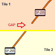
Hi Alexandre,

the better solution would be to change your generator so that
it writes the data in the expected order (nodes, ways, relations, each with
ascending ids). If you do that, you can remove the options --mixed and --overlap
and use the default --keep-complete=true.

A possible compromise:
I have to double check that, but I think the keep-complete option only requires that
the ids are sorted, it doesn't care about the order of the elements.
On the other hand, the xml parser requires the
mixed option when the element types are not sorted,
and a check prohibtis the combination of --mixed  and keep-complete=true.
If I am right, I can remove this check.

Ciao,
Gerd

Date: Sat, 30 May 2015 09:15:19 -0300
From: alexandre.loss at gmail.com
To: mkgmap-dev at lists.mkgmap.org.uk
Subject: Re: [mkgmap-dev] Splitter problem: losing a track segment

Hi Gerd,
Overlap of 10000 fixed my problem. :-)
Thank you very much!
Alexandre
2015-05-30 8:20 GMT-03:00 Alexandre Loss <alexandre.loss at gmail.com>:
Hi Gerd,
Thanks for your answer.I'll try your suggestion and give you a feedback about the result.
Regards,
Alexandre
2015-05-30 5:43 GMT-03:00 Gerd Petermann <gpetermann_muenchen at hotmail.com>:


Hi Alexandre,

I don't have much time to analyse your data today.
I think splitter assumes that the tile boundaries
are
"multiples of 0x200 map units wide and high"
when you use resolution=15.

Since you use keep-complete=false you have to watch
the overlap value.
You can use a larger overlap value like 10000 to fix this problem.

Gerd


Date: Fri, 29 May 2015 22:04:34 -0300
From: alexandre.loss at gmail.com
To: mkgmap-dev at lists.mkgmap.org.uk
Subject: [mkgmap-dev] Splitter problem: losing a track segment

Hi guys,
I'm facing a problem in one of my maps, that is probably might be happening in other places where I didn't see yet.
The problem can be seen in the figure below taken from MapSource. There is a gap in a track on the border of the tiles:


So I started to analyze the problem step-by-step till find that the problem was generated by Splitter (last version).

To simplify your analysis, I edited my .osm file before running Splitter and remove all objects (nodes, lines, poi, etc.) not related to the problem, leaving only the line where the problem happens. The result was the file "93352150-Ribeirao_Preto.osm" attached, containing only this:

<?xml version="1.0" encoding="UTF-8"?><osm version="0.6" generator="TSuite 6.6.0.4"><!-- === POLYLINE ROTEAVEL - INICIO: SP-255 DANIELLE ======================== -->
 <node id="576" lat="-21.9388623" lon="-48.3347007" visible="true" version="1"/> <node id="805" lat="-21.8877920" lon="-48.2932640" visible="true" version="1"/> <node id="806" lat="-21.8674906" lon="-48.2767485" visible="true" version="1"/> <node id="804" lat="-21.8661147" lon="-48.2756044" visible="true" version="1"/> <way id="803" visible="true" version="1">  <nd ref="576"/>  <nd ref="805"/>  <nd ref="806"/>  <nd ref="804"/>  <tag k="highway" v="trunk"/>  <tag k="name" v="SP-255 DANIELLE"/>  <tag k="ref" v="SP-255"/>  <tag k="addr:city" v="BOA ESPERANÇA DO SUL"/>  <tag k="addr:state" v="SP"/>  <tag k="addr:country" v="Brasil"/> </way><!-- === POLYLINE ROTEAVEL - FIM: SP-255 DANIELLE ======================== --></osm>

Then I ran Splitter on this file and the result was the file "93352150.osm" (attached and compacted), whose content are the lines bellow:

<?xml version='1.0' encoding='UTF-8'?><osm version='0.5' generator='splitter' upload='false'><bounds minlat='-21.895751953125' minlon='-50.262451171875' maxlat='-20.401611328125' maxlon='-47.548828125'/><node id='805' lat='-21.8877920' lon='-48.2932640'/><node id='806' lat='-21.8674906' lon='-48.2767485'/><node id='804' lat='-21.8661147' lon='-48.2756044'/><way id='803'><nd ref='576'/><nd ref='805'/><nd ref='806'/><nd ref='804'/><tag k='highway' v='trunk'/><tag k='name' v='SP-255 DANIELLE'/><tag k='ref' v='SP-255'/><tag k='addr:city' v='BOA ESPERANÇA DO SUL'/><tag k='addr:state' v='SP'/><tag k='addr:country' v='Brasil'/></way></osm>
Note that in the "93352150.osm" file is missing the node 576 definition (i.e.: <node id="576" lat="-21.9388623" lon="-48.3347007" visible="true" version="1"/>).
And this is the cause of the lost segment.
I'm running Splitter in the following way:
java -jar splitter.jar --split-file=93352150-Ribeirao_Preto.list --max-areas=1024 --mixed=true --keep-complete=false --resolution=15 --output=xml 93352150-Ribeirao_Preto.osm
The above .list file is attached.
If this is not a Splitter error, please, let me know what I'm doing wrong.
Thanks.
Alexandre


_______________________________________________
mkgmap-dev mailing list
mkgmap-dev at lists.mkgmap.org.uk
http://www.mkgmap.org.uk/mailman/listinfo/mkgmap-dev

_______________________________________________

mkgmap-dev mailing list

mkgmap-dev at lists.mkgmap.org.uk

http://www.mkgmap.org.uk/mailman/listinfo/mkgmap-dev


_______________________________________________
mkgmap-dev mailing list
mkgmap-dev at lists.mkgmap.org.uk
http://www.mkgmap.org.uk/mailman/listinfo/mkgmap-dev
-------------- next part --------------
An HTML attachment was scrubbed...
URL: <http://www.mkgmap.org.uk/pipermail/mkgmap-dev/attachments/20150602/a47ff6dd/attachment-0001.html>
-------------- next part --------------
A non-text attachment was scrubbed...
Name: image.png
Type: image/png
Size: 9577 bytes
Desc: not available
URL: <http://www.mkgmap.org.uk/pipermail/mkgmap-dev/attachments/20150602/a47ff6dd/attachment-0001.png>
- Previous message: [mkgmap-dev] Splitter problem: losing a track segment
- Next message: [mkgmap-dev] Splitter problem: losing a track segment
- Messages sorted by: [ date ] [ thread ] [ subject ] [ author ]
More information about the mkgmap-dev mailing list